Meteorologist Myles Henderson’s First Warning Forecast
Looking good for most of Labor Day weekend. Tracking showers and storms for early next week.
Another nice day with a mix of mostly sunny to partly cloudy skies. Highs will return to the upper 80s with a slight increase in humidity.
This weekend looks nice! We will see partly cloudy skies with slim rain chances both days. Highs will return to the mid and upper 80s, just a few degrees above normal for this time of year.

Showers and storms are set to return for Labor Day and early next week with an approaching cold front. Expect partly to mostly cloudy skies on Monday with showers moving in by the afternoon to evening. An isolated storm is possible.

Today: A Few Clouds. Highs in the upper 80s. Winds: E 5-10
Tonight: Partly Cloudy. Lows in the upper 60s. Winds: E 5-10
Tomorrow: Partly Cloudy. Highs in the upper 80s. Winds: E 5-10
Weather & Health
Pollen: High (Ragweed, Grasses)
UV Index: 8 (Very High)
Air Quality: Good (Code Green)
Mosquitoes: Extreme
Tropical Update
Danielle becomes the first Atlantic hurricane of the season. Hurricane Danielle is centered about 885 miles west of the Azores. The hurricane is forecast to meander over the open Atlantic during the next couple of days, then slowly turn toward the northeast early next week.
Maximum sustained winds have increased to near 75 mph with higher gusts. Some additional strengthening is forecast during the next couple of days.

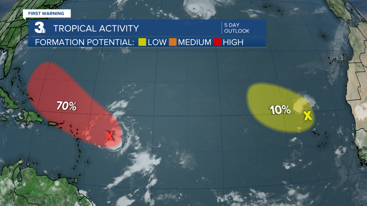
Satellite imagery indicates there has been little change in the organization of the area of low pressure located several hundred miles east of the Leeward Islands during the past several hours. Although environmental conditions remain only marginally conducive, any additional development of the system over the next few days would lead to the formation of a tropical depression. The disturbance is expected to move slowly WNW, toward the adjacent waters of the northern Leeward Islands.
* Formation chance through 48 hours: Medium (50%)
* Formation chance through 5 days: High (70%)
Shower activity associated with a broad area of low pressure located just northwest of the Cabo Verde Islands has increased some over the last several hours but remains poorly organized. This system is moving into an area of less favorable environmental conditions, and significant development is not anticipated.
* Formation chance through 48 hours: Low (10%)
* Formation chance through 5 days: Low (10%)

Weather updates on social media:
Facebook: MylesHendersonWTKR
Twitter: @MHendersonWTKR
Instagram: @MylesHendersonWTKR


