Meteorologist Myles Henderson’s First Warning Forecast
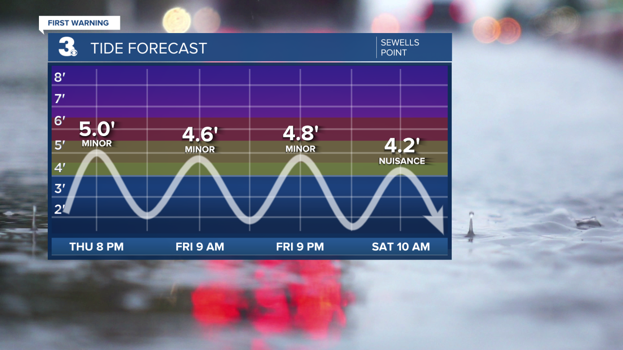
***Coastal Flood Advisory... Minor level flooding near times of high tide Thursday and Friday.

A windy end to the work week with clearing skies and lower rain chance. Highs in the mid 80s with building clouds this weekend.
Expect partly cloudy skies today with a few showers possible. Highs will only reach near 80, a few degrees below normal for this time of year. It will be windy today with NE winds at 10 to 20 mph and higher gusts. The strong NE winds combined with the rough surf from Hurricane Earl could trigger some minor coastal flooding.

It will still be windy tomorrow with NE winds at 10 to 20 mph. We should see more sunshine, mostly sunny to partly cloudy skies. Highs will return to the low 80s.
Expect highs in the mid 80s this weekend with relaxing winds. We will see partly cloudy skies on Saturday with more clouds building in on Sunday. Rain chances will be low this weekend but will increase to start next week as a cold front moves our way.

Today: Mix of Clouds, Scattered Showers. Highs near 80. Winds: NE 10-20
Tonight: Clearing Skies. Lows in the upper 60s. Winds: NE 5-15
Tomorrow: A Few Clouds. Highs in the low 80s. Winds: NE 10-20
Weather & Health
Pollen: Medium-High (Ragweed, Grasses)
UV Index: 6 (High)
Air Quality: Good (Code Green)
Mosquitoes: Extreme
Tropical Update
Danielle is now a post-tropical cyclone over the north Atlantic. Maximum sustained winds have decreased to near 65 mph with higher gusts. Danielle is forecast to remain a large post-tropical cyclone over the north Atlantic for the next several days, even as its peak winds slowly decrease.

Hurricane Earl is centered 230 miles south of Bermuda and moving NNE at 13 mph. On the forecast track, the center of Earl is expected to pass to the southeast of Bermuda tonight and continue tracking generally NE. Maximum sustained winds are near 105 mph with higher gusts. Additional strengthening is forecast during the next couple of days, and Earl is expected to become a major hurricane later today. The hurricane is forecast to become a powerful post-tropical low by Saturday night.

An area of low pressure located almost a thousand miles WNW of the Cabo Verde Islands is producing a concentrated area of disorganized showers and thunderstorms primarily east of its center. Environmental conditions appear only marginally conducive for additional development of this system, but only a small increase in organization could result in the formation of a short-lived tropical depression or storm later today while it moves west to WNW at 15 to 20 mph over the central tropical Atlantic.
* Formation chance through 48 hours: High (70%)
* Formation chance through 5 days: High (70%)
A tropical wave has emerged off the west coast of Africa this morning and is producing an area of disorganized showers and thunderstorms. Environmental conditions appear conducive for some gradual development as the system moves generally WNW over the eastern tropical Atlantic.
* Formation chance through 48 hours: Low (0%)
* Formation chance through 5 days: Low (30%)

Weather updates on social media:
Facebook: MylesHendersonWTKR
Twitter: @MHendersonWTKR
Instagram: @MylesHendersonWTKR


