


Our News 3 weather team is tracking Hurricane Helene and providing you live updates as they come in.
UPDATE 9/27/24 8 p.m.
Southeastern Virginia is no longer under a tornado watch
UPDATE 9/27/24 5:55 p.m.
A Tornado Watch remains in effect until 8 p.m. for southeastern Virginia.

Current Conditions
- Humidity: 76%
- Dew point: 49°
- Pressure: 30.17 in
- Wind speed: 8 mph
- Wind direction: SSW
- Visibility: 10.0 mi
- Sunrise: 06:59 AM
- Sunset: 07:22 PM
UPDATE 9/27/24 2:51 p.m.
Helene is now a tropical depression but we're still monitoring for isolated tornado possibilities here at home this afternoon. -Derrah Getter

UPDATE 9/27/24 11:38 a.m.
Tropical Storm Helene in producing catastrophic flooding over portions of the southeast and southern Appalachians. Helene is forecast to stall over the Tennessee Valley tonight and through the weekend.
Maximum sustained winds have decreased to near 45 mph with higher gusts. Continued weakening is expected, and Helene is forecast to become extra tropical later today.
Tropical-storm-force winds extend outward up to 345 miles east of the center.

Hurricane Isaac heading east over the north central Atlantic. An east to ENE motion is expected over the next several days. Additional strengthening is expected during the next day or so followed by gradual weakening by the end of this weekend.
Tropical Storm Joyce forms over the central tropical Atlantic. A northwest to north motion is expected over the next few days. Gradual strengthening is expected through Saturday, followed by gradual weakening early next week. - Myles Henderson

UPDATE 9/27/24 8:10 a.m.
A tornado watch has been issued for coastal Va, and N.C. The watch remains in effect until 6 p.m. - Myles Henderson

UPDATE 9/27/24 5:10 a.m.
Helene weakens to a tropical storm as it moves farther inland over Georgia. Helene is expected to turn northwest and slow down over the Tennessee Valley later today and Saturday.
Maximum sustained winds have decreased to near 70 mph with higher gusts. Continued weakening is expected, and Helene is expected to become a post-tropical low this afternoon or tonight.
Tropical-storm-force winds extend outward up to 275 miles mainly to the east of the center. - Myles Henderson


UPDATE 9/26/24 11:20 p.m.
LANDFALL: Hurricane Helene has officially made landfall just east of the mouth of the Aucilla River as a Category 4 hurricane with winds of 140 mph and gusts up to 160 mph. Damage is expected to be catastrophic from this massive storm.

UPDATE 9/26/24 10:15 p.m.
It looks like Helene won't strengthen any more as it starts to move inland. Category 4 hurricanes are fairly rare. We've only seen 144 of them in the Atlantic basin since 1851. - Patrick Rockey

UPDATE 9/26/24 10:00 p.m.
The eye wall of Category 4 Helene is beginning to push ashore in the Big Bend area of Florida. Catastrophic damage expected. - Patrick Rockey

UPDATE 9/26/24 9:00 p.m.
Winds now at 140 mph with Hurricane Helene. Gusts are up to 155 mph. The storm will make landfall in the next few hours and the damage could be staggering. - Patrick Rockey

UPDATE 9/26/24, 8:00 p.m.
Here's Derrah's updated forecast:
UPDATE 9/26/24, 6:30 p.m.
Hurricane Helene is now a monster Category 4 storm.
From the National Hurricane Center:
A NOAA Hurricane Hunter aircraft currently investigating Helene
recently found that the maximum sustained winds have increased to
130 mph (215 km/h).  The minimum central pressure has also decreased
to 947 mb (27.96 inches) based on dropsonde data.

SUMMARY OF 620 PM EDT...2220 UTC...INFORMATION
----------------------------------------------
LOCATION...28.0N 84.5W
ABOUT 120 MI...195 KM W OF TAMPA FLORIDA
ABOUT 165 MI...265 KM S OF TALLAHASSEE FLORIDA
MAXIMUM SUSTAINED WINDS...130 MPH...215 KM/H
PRESENT MOVEMENT...NNE OR 25 DEGREES AT 23 MPH...37 KM/H
MINIMUM CENTRAL PRESSURE...947 MB...27.96 INCHES

UPDATE 9/26/24, 5:30 p.m.
The director of the National Hurricane Center is providing a live update on YouTube right now.
UPDATE 9/26/24, 5:30 p.m.
Hurricane Helene is so strong and moving so quickly that it could still be near hurricane force when moving through Atlanta Friday morning! - Patrick Rockey

UPDATE 9/26/24, 4:45 p.m.
New update from the Hurricane Center shows Helene's winds are now at 125 with gusts to 155 mph. Could hit Category 4 status within the next few hours. - Patrick Rockey

UPDATE 9/26/24, 4:00 p.m.
Helene is a VERY large storm. Take a look at the wind field. The storm is still well off shore, but right now most of Florida is getting tropical storm force winds. - Patrick Rockey

UPDATE 9/26/24, 2:30 p.m.
Helene is officially a major hurricane.
From the National Hurricane Center: "The Air Force Hurricane Hunters found that the maximum sustained winds have increased to near 120 mph (195 km/h). This makes Helene a dangerous category 3 major hurricane. Additional strengthening is expected before Helene makes landfall in the Florida Big Bend this evening."
UPDATE 9/26/24, 2:00 p.m.
Helene is just below category 3 strength. Currently winds are at 110 miles per hour. Category 3 strength winds range from 111-129 miles per hour. - Derrah Getter

UPDATE 9/26/24, 11:03 a.m.
Hurricane Helene is strengthening and is expected to make landfall in the Florida Big Bend this evening as a major hurricane.
UPDATE 9/26/24, 11:00 a.m.
Helene is gaining strength. A large eye has become apparent in satellite images. Rain is beginning to wrap around the eye and it is almost completely closed. The pressure has been dropping steadily to near 960 mb based on aircraft flight-level wind data. Tropical storm-force winds have started to reach portions of South Florida and the Florida Keys. The hurricane has turned slightly farther to the northeast. - Derrah Getter
UPDATE 9/26/24, 8:00 a.m.
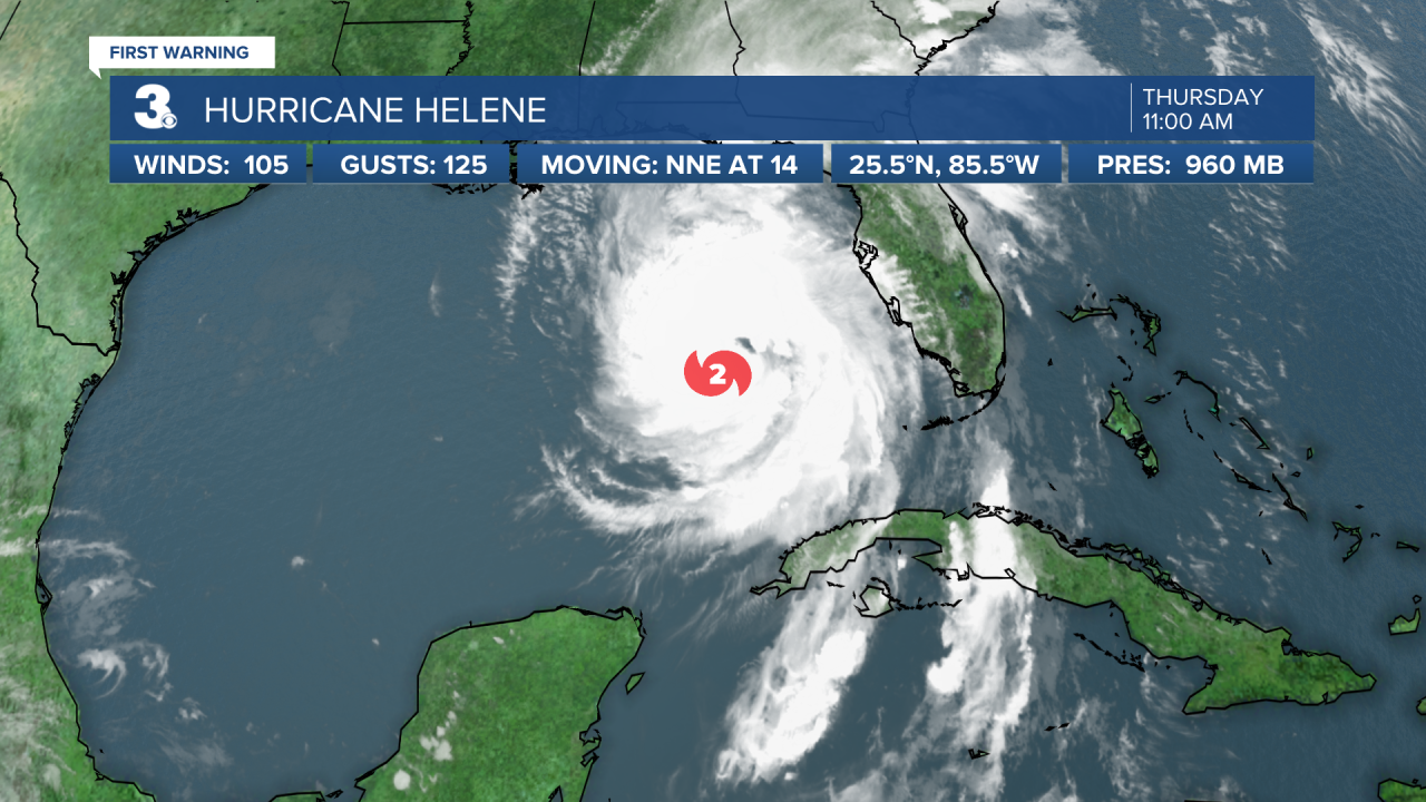
Helene becomes a category 2 hurricane.


UPDATE 9/26/24, 5:00 a.m.
Helene strengthening and expected to bring catastrophic winds and storm surge to the northeastern gulf coast. On the forecast track, Helene will move across the eastern Gulf of Mexico today and cross the Florida Big Bend coast this evening or early Friday morning. After landfall, Helene is expected to turn northwest and slow down over the Tennessee Valley on Friday and Saturday.


Maximum sustained winds have increased to near 90 mph with higher gusts. Strengthening is forecast, and Helene is expected to be a major hurricane when it reaches the Florida Big Bend coast this evening. Weakening is expected after landfall.
Hurricane-force winds extend outward up to 60 miles from the center and tropical-storm-force winds extend outward up to 345 miles. - Myles Henderson


UPDATE: 9/25/24, 11:00 p.m.
Just got the 11 p.m. update from the National Hurricane Center. Little has changed since the 8 p.m. report. Helene is expected to rapidly intensify from a Category 1 to Category 4 status before landfall around the Big Bend in Florida tomorrow night. That would be remarkably fast strengthening. I should mention that the NHS reports that several regional forecast models suggest Helene could have sustained winds even higher than the official forecast. - Patrick Rockey


UPDATE: 9/25/24, 10:15 p.m.
Take a look at the water temperatures ahead of Helene in the Gulf of Mexico. Tropical systems are primarily fueled by warm water (usually 80° or higher). Helene has plenty of gasoline ahead with water temperatures between 85° and 87°. That's why we're expecting rapid intensification tomorrow. - Patrick Rockey

UPDATE: 9/25/24, 10 p.m.
Here's a quick overview of what we're thinking. We'll get a fresh update from the National Hurricane Center at 11 p.m. - Patrick Rockey

UPDATE: 9/25/24, 8 p.m.
Helene is expected to rapidly intensify as it moves into the very warm Gulf waters where water temperatures are near 90 degrees Fahrenheit. It is anticipated to become a category 2 storm by Thursday morning.
From there, it will likely gain enough strength to become a category 4 hurricane before making landfall somewhere near Apalachicola, Florida in the state's Big Bend region late Thursday.
Catastrophic and deadly storm surge is likely along Florida's west coast where inundation could reach as high as 20 feet above ground level.
Watch: Hurricane Helene growing to category 4 storm
UPDATE: 9/25/24, 5 p.m.
Damaging hurricane-force winds will extend well inland over portions of North Florida Thursday where Hurricane warnings are in effect.
Strong wind gusts are also likely farther north across portions of Georgia, the Carolinas and the southern Appalachian Mountains.
Portions of the Southeast could see 6 to 12 inches of rainfall with isolated totals around 18 inches.
The rainfall is likely to produce flash and urban flooding and significant river flooding. Landslides will be possible across the southern Appalachians.
