


HAMPTON ROADS, Va. — A stationary front hovering over the region will drift north Monday, and an impulse from the west along that front will bring increasing shower and thunderstorm chances across the the area.
It won't be a washout Monday, but be prepared for a few showers or storms, with a chance early in the day, and then more widespread showers developing during the afternoon.
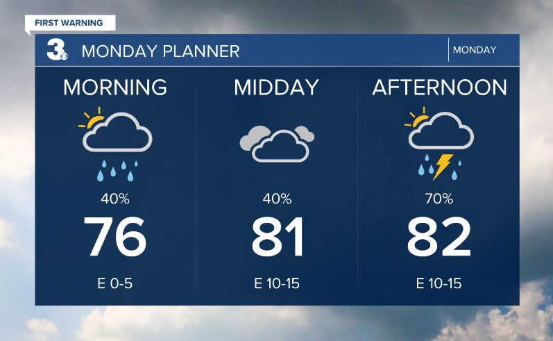
As of this post update Sunday evening, there is a level 1 risk for severe storms Monday for inland areas of eastern North Carolina, but stay tuned for any updates on that into early Monday.

At least the temperatures will be pretty comfortable Monday, but they'll head higher Tuesday and Wednesday before dropping with cooler air from the north Thursday and Friday (and clouds and perhaps rain from Idalia by then too).

If you're at coastal areas, stay extra alert for rip currents (from Hurricane Franklin over the Atlantic), as there will be high rip risk on the Eastern Shore Monday through Wednesday, with Virginia Beach and the Outer Banks officially under a moderate rip risk Monday, but that will likely become a high risk later in the day into at least Tuesday.
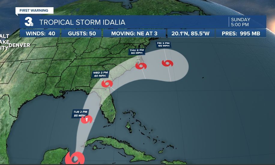
Let's talk about the tropics, and the latest on Idalia. As of the 5 p.m. Sunday update from NHC, Idalia is expected to become a hurricane early this week as it moves into the eastern Gulf, and then is predicted to landfall over western Florida Tuesday night and early Wednesday.
Thereafter, high pressure from the northern tier of the U.S. will try to divert the northward track of Idalia to the northeast and then east by Thursday as it crosses the Carolinas.
This makes it a tricky forecast for our area for later this week. There could be a sharp northern cutoff of where there's a lot of rain vs very little. At this stage, it's early to tell how much rain (or wind) could affect our latitudes, so stay tuned for updates.
Here's our rain probabilities for the next 5 days. The chances could go higher Thursday and Friday depending on track of the storm.

