

Meteorologist April Loveland's First Warning Forecast
Wind Advisory in effect from 10 PM Sunday until 8 PM Monday. North winds 25-35 mph, with gusts up to 50 mph possible. This could lead to downed trees, power lines and power outages.

Coastal Flood Warning in effect from 2 AM Monday until 8 PM Tuesday. Severe flooding will cause extensive inundation and flooding of numerous roads and buildings resulting in a significant threat to property and life. Water will be 2 to 3 feet or more above ground level in some areas. Severe flooding will extend inland from the waterfront and shoreline flooding homes, businesses and isolating some neighborhoods. Numerous roads will be impassable under several feet of water and cars submerged.

Today is looking fine for tidal flooding. We should get through the day without having to worry about that. The next high tide at Sewells Point is 3 PM. Temperatures will be a little cooler with highs in the low 70s. More clouds will build in and the wind will start to ramp up during the afternoon and evening hours. Rain will move in later this afternoon.


All eyes turn toward Monday as Ian's remnants merge with a low off the coast. Winds will continue to crank up. Wind gusts up to 50 mph will be possible. Expect rain at times as well. Moderate to major tidal flooding will be possible at 4 AM Monday. This will definitely cause some issues for folks who head to work early. We will have another round of tidal flooding at 4 PM. This could cause some issues. More people will be on the road and it will be at major tidal flooding levels. Temperatures will be much cooler with highs in the low 60s.
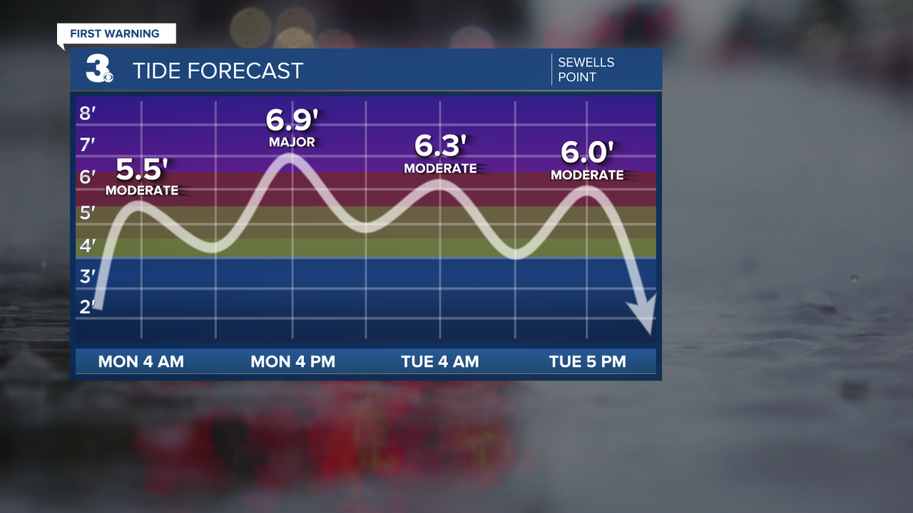
Tidal flooding and gusty winds will continue to be a concern on Tuesday. Expect showers at times with highs upper 50s to near 60. Tidal Flooding will will reach moderate levels at 4 AM and again at 5 PM.

The light at the end of the tunnel comes on Wednesday. It will be much drier with just a few lingering showers and partial clearing. It will be warmer with highs near 70. The winds will begin to relax.

More sunshine will break out for Thursday and Friday. Highs will warm to the mid 70s on Thursday and upper 70s on Friday.

Meteorologist April Loveland
For weather updates on Facebook: HERE
Follow me on Twitter: HERE
Follow me on Instagram HERE
Check out the Interactive Radar on WTKR.com: Interactive Radar
