


Meteorologist April Loveland's First Warning Forecast
A refreshing change with lots of sun today. Highs will sit about 10 degrees below normal in the low 70s. It’s an ideal day to get outside and enjoy the fresh air.
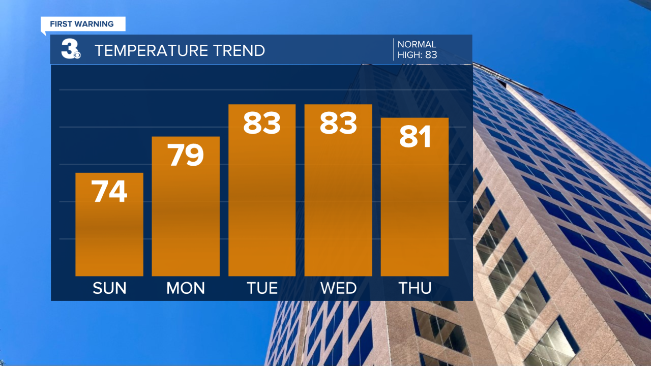
It'll be sunny and comfy to kick off the workweek with highs in the upper 70s.
Lots of sunshine Tuesday continues the sunny streak with highs in the low 80s. With no rain in the forecast, it’s another excellent day to be outdoors.
It'll be mostly sunny Wednesday with highs in the low 80s. Expect a few clouds to dot the sky, but they won’t interfere with your plans.
Thursday brings partly cloudy skies and highs in the low 80s. Rain chances will be slim, so it'll be another fantastic day for outdoor activities.
Friday wraps up the week with highs falling back into the upper 70s. Expect more clouds than sunshine.

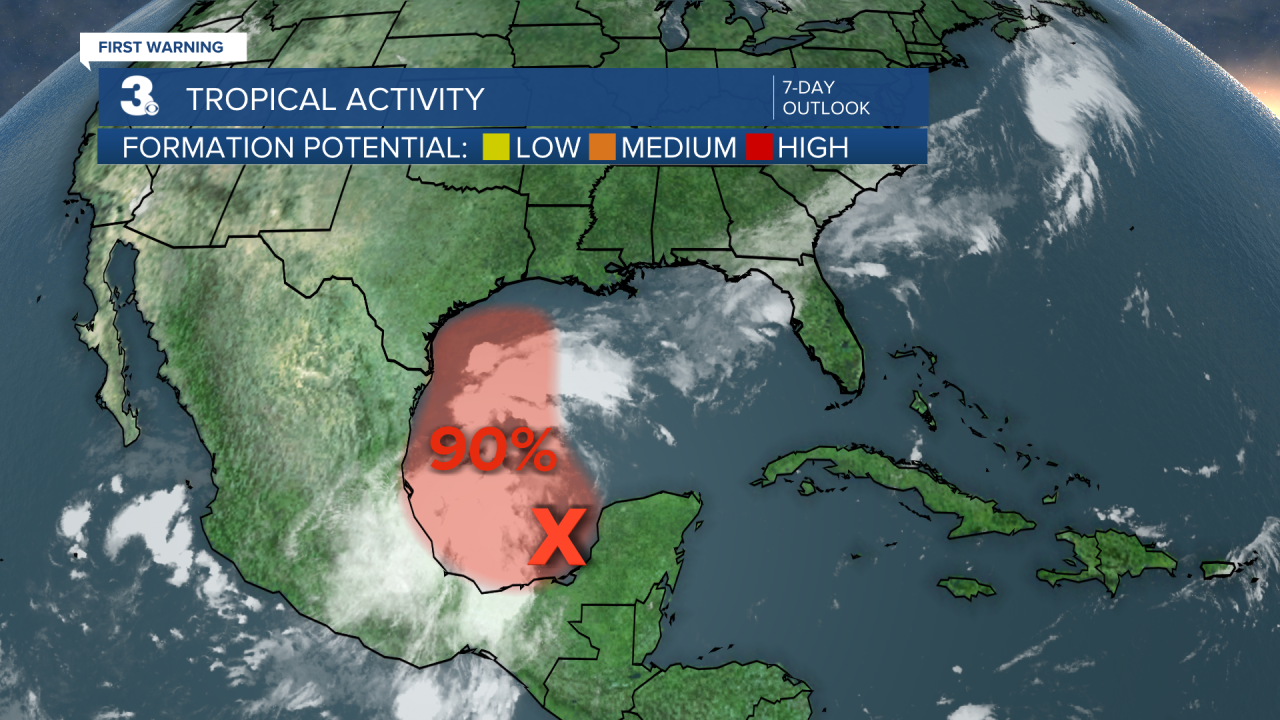
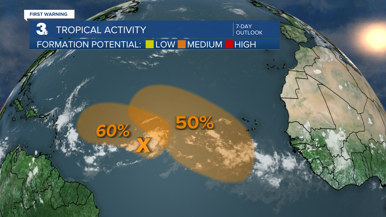
Tropical Update:
Showers and thunderstorms have increased this morning in association with a broad area of low pressure located over the southwestern Gulf of Mexico. This system is forecast to drift slowly northwestward during the next couple of days, and environmental conditions are expected to become conducive for additional development. A tropical depression is likely to form during the next couple of days as the system moves generally northwestward and then northward near or along the Gulf coast of Mexico and Texas through the middle of the week.
* Formation chance through 2 days: HIGH (80%)
* Formation chance through 7 days: HIGH (90%)
Showers and thunderstorms associated with an elongated area of low pressure over the central tropical Atlantic continue to show some signs of organization. Environmental conditions appear conducive for additional development of this system, and a tropical depression could form while the system meanders over the central tropical Atlantic through Monday and then begins to move generally westward at around 10 mph through the rest of the week.
* Formation chance through 2 days: MEDIUM (40%)
* Formation chance through 7 days: MEDIUM: (60%)
A trough of low pressure located several hundred miles southwest of the Cabo Verde Islands is producing a broad area of disorganized showers and thunderstorms. Environmental conditions are expected to be favorable for gradual development of this system, and a tropical depression could form by the middle or latter part of the week while the system begins moving slowly west-northwestward.
* Formation chance through 2 days: LOW (0%)
* Formation chance through 7 days: MEDIUM (50%)
Meteorologist April Loveland
For weather updates on Facebook: HERE
Follow me on Twitter: HERE
Follow me on Instagram HERE
Check out the Interactive Radar on WTKR.com: Interactive Radar
